flyover
Live flight radar for your desk
Setup & Owner's Guide
Three minutes from box to live skies.
Welcome
Flyover shows every aircraft flying near your home in real time — position, callsign, altitude and type — on a round, cockpit-style display. There's no app and no account: give it your Wi-Fi and your location once, and it quietly does its thing for years.
In the box: the Flyover unit and a USB-C power cable.
You'll need: any USB power adapter (a phone charger is perfect), a 2.4 GHz Wi-Fi
network (the device doesn't see 5 GHz-only networks), and a phone or laptop for the one-time setup.
Quick start
1
Plug it in
Connect the USB-C cable to the port at the bottom of the unit and to any USB power adapter. The screen lights up and shows Setup mode.
2
Join its setup network
On your phone, open Wi-Fi settings and join PlaneRadar-Setup. A setup page opens by itself — if it doesn't, browse to 192.168.4.1.
3
Fill in the setup page
Pick your home Wi-Fi, set your location (use the finder just below to get your numbers), choose a range, and save.
That's it. The unit connects, the scope appears, and aircraft fade in
within a few seconds. It remembers everything and starts by itself whenever it has power.
Find your latitude & longitude
For the Home location step. Search your address, tap Use my location, or just tap your home on the map — then copy the two numbers into the device.
Tap the map to drop a pin, or drag the pin to fine-tune.
Latitude—
Longitude—
Enter both numbers exactly as shown. Longitude is negative west of the UK and across the Americas — the map sets the sign for you.
The setup page, field by field
This is what you'll see after joining PlaneRadar-Setup, shown here with example values.
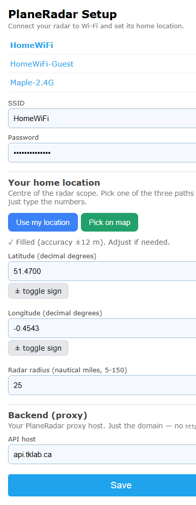
The setup page on your phone.
| Field | What to enter |
|---|---|
| Wi-Fi + password | Tap your network in the list and type its password. Must be a 2.4 GHz network — if your router has separate names per band, use the 2.4 GHz one. |
| Home location | Use the finder above, or on the device tap Use my location, Pick on map, or type latitude/longitude. The ± buttons flip N/S and E/W. |
| Radar radius | How far the scope looks, 5–150 nautical miles. 25 is a great start; change it any time in settings. |
| Backend | Pre-filled with api.tklab.ca — correct for every Flyover. Leave it exactly as is unless we ask you to change it during support. |
| Save | The unit reboots, joins your Wi-Fi, and the radar appears. |
Reading the radar
Your home is the centre dot. The rings mark equal steps of distance out to your chosen range, labelled in nautical miles along the upper-right diagonal. North is up (unless you flip the display in settings).
- Range rings — equal steps of distance; the numbers (nautical miles) run along the upper-right diagonal.
- Aircraft — the nose points the way it's flying. Tap it for callsign, route, type, altitude and more.
- Labels — type code (e.g. B77W), callsign and altitude. Each line can be hidden in settings.
- Numbered bubble — several aircraft packed together (an airport or holding stack). Tap it for a list.
- Centre dot — your home. The i button (bottom) opens settings.
GND as an altitude means the aircraft is on the ground, taxiing or parked
at a nearby airport. You can hide ground traffic entirely in settings.
Settings
Tap the i button at the lower right of the scope. Scroll the panel; tap the X to close.
| Setting | What it does |
|---|---|
| Range | Radar radius, 5–150 nm. The rings re-label to match. |
| Brightness | Screen brightness. |
| Show plane / callsign / altitude | The three label lines by each aircraft — type code (e.g. B77W), callsign, altitude. Toggle each on or off. |
| Show velocity vectors | A thin line from each aircraft showing where it will be in one minute. Longer line = faster. |
| Theme | Eight looks — Classic green, Amber, Glass blue, Night red, Ice, Synthwave, Mono, plus Custom with a hue slider. |
| High contrast | Flips to a light background with dark markings. |
| Aircraft | Icon style — Boxes, Circles, or Planes (arrows that point the way each aircraft is flying). |
| Hide ground | Hides taxiing/parked aircraft at nearby airports. |
| Flip 180° | Turns the picture upside down, for mounting the other way up. |
| Idle sleep | Auto-sleeps the screen after 15 minutes to 5 hours without a touch, or Never. |
| Show connection info | Off by default, so the scope stays clean. Turn it on to see brief status notes (“updating” / “reconnecting”) as data refreshes; with it off, only a long, genuine outage ever shows a message. |
| reconfigure Wi-Fi | Erases all settings and returns to first-time setup. Use when moving house or changing routers. |
Sleep & wake
Tap the moon in settings to sleep now, or let the idle timer do it. Asleep, the screen is off and the radar pauses. Double-tap the screen to wake it.
Automatic updates
Flyover updates its own software over Wi-Fi, even while asleep — nothing to install or click. Just leave it plugged in.
If something looks off
Flyover is built to look after itself: it keeps showing the last aircraft through brief data gaps, reconnects on its own after Wi-Fi or internet outages, and even restarts itself automatically if it ever gets truly stuck — so most things clear up with no action from you.
Messages on the scope
By default the scope stays clean and only speaks up during a long, genuine outage. Turn on Show connection info to also see the brief notes below.
| Message | Meaning |
|---|---|
| waiting for first poll… | Just started; data is seconds away. |
| updating feed… | Fetching a new area — e.g. just after you change the range. Normal; clears on its own. |
| reconnecting feed… | A brief data hiccup. The picture holds and recovers by itself; nothing to do. |
| Wi-Fi disconnected | Lost the router. The unit keeps retrying and reconnects on its own, even after long outages. |
| service unavailable | The flight-data service declined this unit. Message us on Etsy. |
Troubleshooting
| Problem | Try this |
|---|---|
| Screen is dark | Probably asleep — double-tap the screen. Otherwise check the USB cable and adapter. |
| Can't find PlaneRadar-Setup | Unplug, wait five seconds, plug back in. The setup network only appears when the unit isn't configured. |
| Setup page never opened | Stay on the PlaneRadar-Setup network and browse to 192.168.4.1. |
| Won't join my Wi-Fi | Make sure it's a 2.4 GHz network and the password is right. Move the unit closer to the router for setup. |
| No aircraft shown | Quiet skies happen. Try a larger range; coverage depends on volunteer receivers in your area. |
| Aircraft in the wrong place | Re-check your home location: settings > reconfigure Wi-Fi, and set it again (the finder above gives you the numbers). |
| Anything else | Unplug, wait five seconds, plug back in. Still stuck? Message us on Etsy — we can run remote diagnostics while the unit is online. |
Care
Wipe the glass with a dry microfibre cloth. Indoor use only. There's no battery, so unplugging it at any time is completely safe.
Good to know
For your eyes, not for navigation
Flyover is a decorative information display. Positions can be delayed, incomplete or wrong, and some aircraft don't appear at all. Never use it for navigation, flight planning, or any safety or operational decision.
Data sources
Flight data: adsb.lol, a worldwide network of volunteer ADS-B receivers, used under the Open Database License (ODbL 1.0). Route and aircraft details: adsbdb.com. The same attribution appears on the device's settings screen. Map data on this page © OpenStreetMap contributors.
Privacy
The unit sends only what it needs to work: your chosen location and range (to fetch nearby aircraft) and anonymous device-health info. No accounts, no tracking, nothing sold. The map finder above runs in your browser — your location is never sent to us.
Support
Questions, hiccups, ideas: message us on Etsy any time. Include a photo or a quick description of what the screen shows and we'll get you flying again — most issues can be diagnosed remotely while the unit is online.